 Portions of the following information were taken from Florida Geological Survey Bulletin 66.
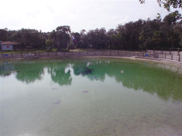
The spring is within Lithia Springs County Park, 5.5 miles (8.9 km) southeast of Brandon.
From the intersection of SR 60 and SR 640, drive south from Brandon on
SR 640 (Lithia-Pinecrest Rd) approximately 6.4 miles to the bridge over the Alafia River.
Travel 0.6 miles past the bridge over the Alafia River, and turn west (right) onto Lithia
Springs Rd. and follow the road 1.5 miles to the park. Admission to the park costs $1.00 per
person. There is no diving permitted.
Description Description Lithia Spring Major is situated within a large, man-modified,
spring pool. The pool measures 168 ft north to south and 180 ft east to west, and depth measured
over the vent is 8.2 ft. The water is clear and blue-greenish. The pool bottom is sand with a
limited exposure of limestone near the vent. The spring pool has steep retaining walls with
several access stairways leading down into the water. The entire bottom of Lithia Spring Major
is bare white sand with sparse algae resulting from use. The vent in the center of the pool is
covered by a barred metal barricade to prevent entry. Spring water discharges through the bars
and a boil was present on the pool surface in April 2002.
The clear, sandy spring run exits east and flows approximately 200 ft, then turns south flowing
approximately 750 ft into the tannic Alafia River. There are some algae and other aquatic
vegetation in the run. Land around Lithia Major is a developed county park. Lithia Spring Minor
joins the Alafia River approximately 100 ft downstream from the mouth of Lithia Spring
Major.
The only access to the system is via a 3' in diameter pipe that leads from the pump house to the
spring. This pipes siphons water from the spring for the purpose of bottling water. The company
with the bottling rights does routinely send divers down through the pipe. It is reported that
there is no permanent line in the system.


