| 8/17/2015 |
Peter McCumber |
100 |
Visibility in the basin was crap, I'd guess less than 10'. Water was warm. Once we reached the gold line, visibility was crystal clear the entire length of the cave. Short and shallow, but beautiful dive. |
| 11/26/2013 |
speleodiver (via CDF) |
50 |
A new passage has been discovered in Church Sink cave system. Exploring through a small pit in the floor, line was added out to 400'. The passage contained clear water with a noticeable temperature change. Clarity is very similar to the known clear water passage encountered on the Ferrell property located in north Wakulla County.
The passage is small (2-3 feet in diameter with many low duck unders only 8 inches tall. Line has been extended out to 1300' and is trending south at a depth of 127'. There are 15 leads off the current line as of now. It is expected the passage will continue down to possibly the 280-300' depth range. Flow is noticeable but not significant as the passage is beginning to open up. |
| 1/16/2011 |
Mat |
60-80' |
Basin and cave looked great, sites closed to public and only divable with permission. |
| 12/3/2010 |
James Garrett |
50ft |
Worst viz I've ever seen here, but still clear. I would *not* suggest back mount for this site if you get landowner permission to dive it, entry would be dangerous, and the first 75-100ft of the cave would require being really far off the line. |
| 12/3/2010 |
James Garrett |
50ft |
Worst viz I've ever seen here, but still clear. I would *not* suggest back mount for this site if you get landowner permission to dive it, entry would be dangerous, and the first 75-100ft of the cave would require being really far off the line. |
| 9/6/2010 |
Mat |
5-100' |
Basin is milky, the cave is not, cave is on private property and closed to the public. |
| 5/9/2010 |
Mat |
2-80' |
Basin is milky, the cave is not. Still closed to diving without the land owners permission. Sink is on private property. |
| 2/28/2010 |
Mat |
100' |
Must get permission from land owner before diving. Basin is clear and the cave is clear. |
| 2/16/2010 |
Mat |
30-60' |
Basin was clear and void of duckweed. Despite our cleanup late last year, trash is again widely distributed in and around the sinkhole. Cave was good, still a closed system that can be dived only with permission from the owner. |
| 9/19/2009 |
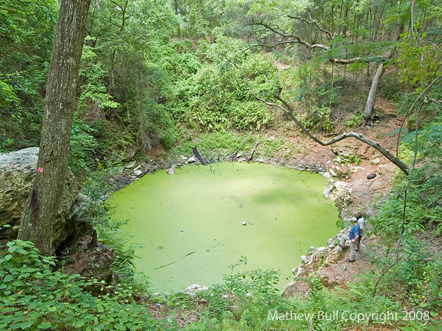
Mathew Bull |
100' |
Church Sink is still closed to diving and is on private property. Participated in a cleanup day at this site, lots of trash was collected and disposed of around the sink itself and along its banks. Collected a bit more from the water itself. Afterwards, we made a dive there wtih the permission of the owner. Beautiful cave, but fragile and silty with no flow. Seemed warmer than the typical panhandle caves at 71F, including other springs/sinks in the area(usually 68F). Perfect visibility and awesome striations along the walls. It would be nice to have regular access to this site. |
| 6/8/2008 |
Buhlz |
?? |
Been wanting to chech this site out! Wow, realyy cool place. I wish people would stop trashing this place. It's probably going to be closed so I need to dive this ASAP. Massive amounts of duckweed on top. This place reminds me alot of Alachua or Mill creek with no steps. It has rope swings and tree drop offs! Really neat but the trash is definatley a problem. I put an underwater camera in there to try and get a peak but nothing. I'm sure when I dive this, I end up pulling something out of there. Long way down to the basin!!! |


 Equipment Configuration and Notes: SM entrance, several hundred feet of BM cave, some of the side passages are SM.