United States » Blind Spring

  • Currently 2.4/5 Stars.
  • 1
  • 2
  • 3
  • 4
  • 5

Rated 2.4/5 stars (302 ratings) Thanks for rating this cave system!

Overview Location & Specifics Conditions Resources Nearby Systems  
Portions of the following information were taken from Florida Geological Survey Bulletin 66.

Blind Spring is located 5.2 mi southwest of the town of Chassahowitzka at the head of Blind Creek, which flows west into the Gulf of Mexico. Access to the spring is by water only. The spring can be reached by boating out the mouth of the Chassahowitzka River and south approximately 1.8 miles to Blind Creek.

Description - Blind Spring has a roughly circular spring pool measuring 90 ft in diameter. Depths near the center reach 55 ft. There are submerged limestone shelves along the north side of the pool. Algae and dark silt deposits are common along the bottom and sides of the spring. In March 2003, during a period of heavy rain, there was a large boil on the spring surface, and the water was extremely tannic and murky. The water reportedly becomes clear and bluish during drier periods. Blind Spring is the reemergence of a subterranean section of Blind Creek. Blind Creek forms in the eastern edge of the Chassahowitzka Swamp. Beauford Spring is near the head waters of Blind Creek. From Beauford Spring, Blind Creek travels approximately 2.8 miles northwest and into a siphon. The siphon is approximately 0.7 miles southeast of Blind Spring. The creek flows underground toward Blind Spring and reemerges as Blind Spring. From Blind Spring, the creek travels another 1.8 miles north and west through open brackish and salt marsh to the Gulf of Mexico. Blind Spring and lower Blind Creek are tidally influenced. Swift tidal currents have scoured the limestone bottom for a few hundred feet below Blind Spring. There are numerous limestone fissures and vent openings in and along the first 400 ft of Blind Creek below Blind Spring. A private fishing cabin on stilts is along the east side of Blind Creek approximately 500 ft downstream from the spring. Blind Spring is situated on the west side of the Chassahowitzka National Wildlife Refuge, at the ecological boundary between coastal palm-hardwood-cedar hammock and open salt marsh.
Click the map below for all mapping options.
Click to View Larger Map
Latitude: 28.657628
Longitude: -82.634766
Zone:
Coordinate System:
Maximum Depth: 180'
 Cave Diving
 Cavern Diving
 Open Water Diving
Date Submitter Visbility Remarks
11/29/2009 Jack Marut 3-5 or less 
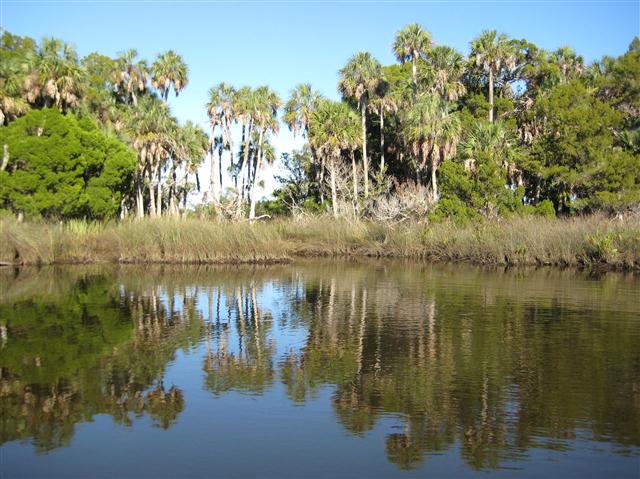
Bill and I made the trip into Blind Spring Final Exsurgence on 11/29/09. We launched our boat at the public ramp at the south end of Pine Island and proceeded north approximately 7 miles and then turned east into South Blind Spring creek. From there we proceeded slowly upstream past half a dozen fishing cabins to the head pool of the final exsurgence of Blind Spring, finally arriving about two hours before high tide. During the last 500 feet of our trip we saw numerous fissures and vents on the mostly moss and silt covered limestone creek bottom. There is quite a lot of flow but it seems to emerge from many places. The head pool is approximately 150 feet in diameter. Visibility was 3-5 feet or less. The water was brackish, 71 degrees, with no hydrogen sulfide smell or taste. There is a fracture running part way across the bottom of the head pool that was 20 – 40 feet deep. There are large passages at the bottom of the fracture that I penetrated a hundred feet or so. There was very low flow, lots of sediment/particulates in the water and plenty of silt on the walls, ceiling and floor. I found no lines in the cave system, nor did I leave any. Visibility in the cave was very poor. I posted a short video at http://www.youtube.com/watch?v=lRxkTMjOajw Dive Safe. Jack
10/2/2009 Jack Marut 10-20 I finally processed the video that I took during our 4/25/09 trip to blind spring head pool. It can be viewed at http://www.youtube.com/watch?v=zIvWI7lL2xQ. Dive Safe. Jack Marut
5/6/2009 Jack Marut 15-20 ft. Bill and I made the trip into Karst Pond located .3 miles ENE of Blind Spring head pool today. The trip was VERY challenging but worth the effort. The north end of the pond features a limestone wall descending and undercutting into a cavern and then a cave with the bottom below 110 ffw. The water temperature was 72º and had a green and slightly milky or foggy appearance just like the water emerging from the Blind Spring head pool .3 miles away. There was no hydrogen sulfide smell or taste. The cave had very low flow, but because it was not filled with silt, I suspect it has more flow during the rainy season. I have posted a video of our Karst Pond dive at http://www.youtube.com/watch?v=fJhsiSQy1AI. Please email me at jmarut@pasco.k12.fl.us if you have any information on Karst Pond or Blind Spring. Dive Safe
4/25/2009 Jack Marut 8-12ft Bill and I made the trip into Blind Spring today. It is a little over 2.75 miles each way. While this is a long trip and difficult trip, it was not as bad as we expected. We parked where Two Mile Tram meets Three Bridges Road. Two Mile Tram is the next road on the right after the Buford road. We walked almost to the end of Two Mile Tram, about 1.3 miles, where it opens up and bends to the left. From there we headed to the right in a NNE direction about a .5 miles through the swamp, toward the end of Main Grade Road, an old road left over from the logging days. When we found Main Grade, with the help of GPS, we followed it northward and then westward about .75 miles. At this point we again headed into the swamp for a final .4 miles or so of very difficult travel, ending our journey at the Blind Spring head pool. The visibility was poor, milky 8-12ft., and the water cold. The bottom of the head pool and spring run are covered with a thick growth of moss-like vegetation. Just brushing this stuff ruins the viz. There is a fracture near the head of pool that runs roughly north-south for 2/3 the width of the pool with depths in the 30-50 foot range. The pool is fairly large, but due to the very poor visibility and lack of scuba gear, we were not able to get a good panoramic view of it. We were not able to find a spring vent or noticeable flow. On numerous free dives into the system we were able to find several large undercuts and a couple of possible tunnels that are large enough to merit additional exploration. Hopefully, we will be able to return in the next few weeks. On our return trip we explored a sinkhole or Karst window about .3 miles to the east and north of Blind Spring. Hunters had told us that this was a man-made quarry and was known as Chevy Sink, for an old car that had been abandoned there years ago. Our investigation revealed that this is definitely a natural formation and that there is no Chevy to be found. I suspect that Chevy Sink is farther north along Main Grade road. In the KUR report this pond and several others are known simply as Karst Window. If anyone knows the correct name for this pond please let me know. This is a large pond, 300 ft or more long and about 2/3rds as wide. The water was cold, very clear and had a slight bluish tint. The northern side of the pond appears to have a deep canyon or cliff like structure in the water about 5-10 feet from shore. This fracture is reported to be 130ft. deep, but without scuba gear, we could not confirm the depth or the report that there is an opening near the bottom. Because we had spent so much time snorkeling the Blind Spring pool, we did not snorkel this pond. We are planning a trip back in a week or so with gear and will let everyone know what we find. If you know anything about this pond please email me. Dive Safe
Click here if you would like to contribute any information or resources for this system.
Description Type Date Author Remarks
 Movie YouTube 2009 Jack Marut
Sslect Search Radius:
System Depth Cave Cavern OW Last Report Distance (mi)
 Overview Information Available for Eagles Nest  Eagle's Nest 315 True False False 3/14/2024 7.3
 Overview Information Available for Buford Spring  Buford Spring 167 True True False 3/14/2024 3.2
   Lost 40 165 True False False 7/15/2023 10.2
 Overview Information Available for Hospital Hole  Hospital Hole 143 False True True 4/30/2023 8.8
 Overview Information Available for Crab Creek Springs  Crab Creek Springs 60 True False False 1/14/2023 5.4
   Warm Springs 140 False True False 11/1/2022 2.8
   Bulldozer Sink 60 False True True 3/22/2020 8.6
 Overview Information Available for Diepolder III  Diepolder III 300 True False False 5/27/2017 11.3
   Little Gator Siphon 180 True False False 1/3/2015 3.1
 Overview Information Available for Twin Dees  Twin Dees 335 True False False 8/3/2013 10.5
 Overview Information Available for Weeki Wachee Spring  Weeki Wachee Spring 407 True False True 4/28/2012 10.4
 Overview Information Available for Diepolder II  Diepolder II 360 True False False 12/23/2010 11.6
   Gator Spring 192 True False False 12/6/2009 7
 Overview Information Available for Little Salt Spring  Little Salt Spring 240 True False False 9/23/2008 7.8
 Overview Information Available for Mud Spring  Mud Spring 210 True True False 11/20/2005 7.7
 Overview Information Available for Hospital Spring  Hospital Spring 40 False True False 8.8
   Nursery Sink 214 True False False 10.6
 Overview Information Available for Jenkins Creek  Jenkins Creek 50 True False False 9.4
 Overview Information Available for Marys Sink  Mary's Sink 58 True False True 10.3
 Overview Information Available for Homosassa Springs  Homosassa Springs 67 False False True 10.2
 Overview Information Available for Joes Sink  Joe's Sink 60 True False True 10.3
 Overview Information Available for Ryles Spring  Ryles Spring False False False 2.4
   Snake Eyes False False False 7.1