United States » Holmes Blue

  • Currently 2.5/5 Stars.
  • 1
  • 2
  • 3
  • 4
  • 5

Rated 2.5/5 stars (291 ratings)

Overview Location & Specifics Conditions Resources Nearby Systems  
Portions of the following information were taken from Florida Geological Survey Bulletin 66.

Holmes Blue Spring is located on the west bank of the Choctawhatchee River 1.4 miles northeast of the community of Cerrogordo. Exit I-10 at SR 279 and turn north toward Caryville. Go 1 mile to the intersection of SR 279 and US 90. Turn west (left) and drive 2.5 miles to the intersection of US 90 and SR 179A/181. Turn north (right) and follow 179A for 5 miles to Cerrogrodo. In Cerrogordo, turn east (right) toward the river and follow signs to boat ramp about 0.5 miles. From the public boat ramp in Cerrogordo, travel 1.5 miles upstream on the Choctawhatchee River to the mouth of the spring. The narrow spring run flows in from the northwest (left) bank.

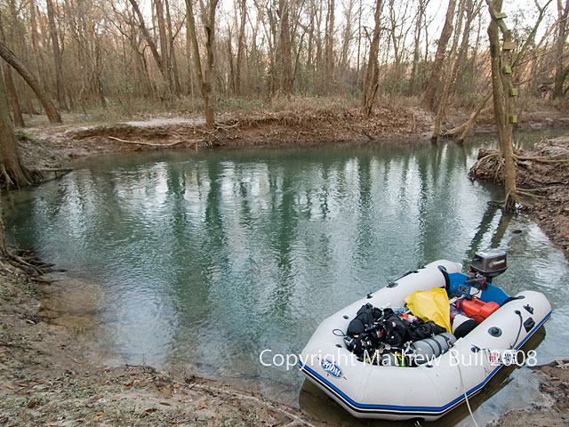
Description - Holmes Blue Spring has a circular spring pool that measures 30 ft in diameter. The vent is a deep, vertical, steep-walled opening in limestone over which the depth measures 29.2 ft. The spring sits in a conical, circular depression with 8 ft high clay banks. Limestone is exposed near the circular vent in the center of the depression. Its waters are bluish and crystal clear. A copious boil emerges over the vent, and water flows approximately 3 in. higher that the surrounding spring surface. There are a few sticks and logs on the sand, clay, and limestone bottom. There is no aquatic vegetation in the spring or its run. The short spring run averages 3 ft deep and flows 150 ft southeast into the murky brown Choctawhatchee River. Spring-water levels are closely tied to fluctuations of the nearby river. The spring run is under a forest canopy within the heavily wooded river floodplain.

Utilization - Holmes Blue Spring is undeveloped and exists in a natural condition.
Click the map below for all mapping options.
Click to View Larger Map
Latitude: 30.85167
Longitude: -85.885847
Zone:
Coordinate System:
Maximum Depth: 90'
 Cave Diving
 Cavern Diving
 Open Water Diving
Ebro Blue
Date Submitter Visbility Remarks
3/25/2013 Bil Lindstrom 100' River is WAY up. Basin has zero viz but there is still a strong boil. Once in the hole, viz opened up to plus 100' easily. The line was loose and flapping around in several places. Fixed as best as I could. I turned at about 96' depth (not sure of the linear - the line isn't knotted. At my turn point, the already small cave cinched way down. Line continues but it appears to be sanding where I turned.
5/4/2012 Zach Skipper 100 River is very low as well as the basin. Water is crystal clear and flow is strong.
5/13/2011 sechristmas 50 This spring originally had a smaller sister spring about 50 feet down the same run toward the river and locals considered this a two spring site. Last time I saw the other spring before sand clogged it up was around 1975 and the last time I dove this was in 1986. It's a nice clear & forceful spring. I've always wondered if the other vent could be cleared and reopened. I first visited this spring sometime around 1970.
7/24/2009 Mathew Bull 100' Basin and Cave were crystal clear
5/1/2009 Mathew Bull 100' Basin was milky due to slightly high river levels, flow kept the cave crystal clear. Outflow seems slightly down.
3/14/2009 Mathew Bull 100' Basin is crystal clear and the cave is every bit as clear, and pumping damned hard.
12/27/2008 Mathew Bull 100' Basin was milky blue due to high water levels in the river, but there was a strong boil with crystal clear water being expelled. Cave was as clear.
Click here if you would like to contribute any information or resources for this system.
Description Type Date Author Remarks
Sslect Search Radius:
System Depth Cave Cavern OW Last Report Distance (mi)
 Overview Information Available for Vortex Spring  Vortex Spring 157 True True True 2/23/2021 6.7