


United States » Rose Creek - Swallet |
| Overview | Location & Specifics | Conditions | Resources | Nearby Systems |
 Portions of the following information were taken from the Dyal and Black Sinks Dye Trace Report conducted in 2003.
 Rose Creek flows from east to west, terminating at Rose Creek Swallet in Columbia City. Rose Creek Swallet and Sink lie below the southwest front of the Cody Escarpment. This geologic feature is where Rose Creek, an intermittent stream draining a portion of the Northern Highlands south of Lake City, disappears into a cave in the underlying limestone. Rose Creek Sink and Swallet are approximately 3.25 miles south-southwest of Black Sink, and approximately 2.5 miles south of Dyal Sink.
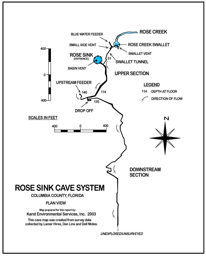
The Rose Creek Cave System includes two surface expressions: Rose Creek Sink and Rose Creek Swallet. The Rose Creek Cave System is located in Columbia City, on the northeast corner of the intersection of Highways 47 and 240.
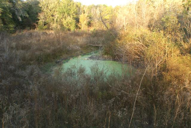
Rose Creek Swallet is circular, approximately 10 feet in diameter, and lies roughly 200 feet northeast of Rose Creek Sink. The swallet is nearly 50 feet deep with vertical walls, and is currently the furthest upstream point in the cave system. Rose Creek Swallet is the surface termination point of Rose Creek and during normal flow captures the entire flow of Rose Creek. During periods of flooding, both Rose Creek Swallet and Sink capture the flow of Rose Creek, with the larger sink receiving the overflow.
Rose Creek Sink is roughly circular and approximately 75 feet in diameter. This sink gradually deepens from the north-end to the south-end where it attains a maximum depth of 20 feet. Several groundwater vents are located in the western sink wall and supply water to Rose Creek Sink at a depth of 15 feet. Rose Creek Sink is the easiest and safest entry point to gain access to the cave. The cave entrance is located along the southeast wall of the Sink; is 26 feet high and 66 feet wide.
Rose Creek Swallet and Sink are connected via a small tunnel named the Swallet Tunnel. The Swallet Tunnel connects to the main cave system approximately 70 feet southeast of the main cave entrance. The Swallet Tunnel is a horizontal, phreatic passage, roughly 10 feet in diameter, over three hundred feet long, and averages 50 feet deep. The Swallet Tunnel is largely free of sediments due to the high water velocities that regularly flow through it. The upstream section nearest the Swallet contains significant amounts of visible bacteria. The Swallet Tunnel is littered with organic debris such as tree limbs to leaves, and manmade trash and debris.
The upper section of the Rose Creek Cave System is a series of roughly circular collapse rooms interconnected by solutionally enlarged, vertical joints. Approximately 700 feet downstream of the main entrance, the main water source, the Upstream Feeder, and the
| Date | Submitter | Visbility | Remarks |
|---|---|---|---|
| 2/5/2011 | Walter Pickel | 50-60 | Very little flow in the swallet side of this system. There was limited life and a lot of organic debris. Flow was not noticeable. |
| Description | Type | Date | Author | Remarks |
|---|---|---|---|---|
| 2003 | KES | |||
| Map | 2003 | KES |
| System | Depth | Cave | Cavern | OW | Last Report | Distance (mi) |
|---|---|---|---|---|---|---|
| 80 | 1/12/2023 | 7.3 | ||||
| 80 | 10/15/2022 | 10.8 | ||||
| 165 | 7/4/2011 | 0.1 | ||||
| 150 | 3/1/2009 | 0.7 |