United States » Turtle Spring

  • Currently 3/5 Stars.
  • 1
  • 2
  • 3
  • 4
  • 5

Rated 3/5 stars (306 ratings) Thanks for rating this cave system!

Overview Location & Specifics Conditions Resources Nearby Systems  
Portions of the following information were taken from Florida Geological Survey Bulletin 66.

Turtle Spring is located 8 miles southeast of Branford on the west side of the Suwannee River. From the bridge over the Suwannee River in Branford head west on US 27/20 approximately 1.3 miles to the intersection with SR 349. Head south (left) on SR 349 and drive approximately 7.3 miles to the second CR 342 intersection with CR 349 (second CR 342 sign – CR 342 loops around and joins CR 349 at two points). Turn east (left) onto CR 342 and drive approximately 5 miles to the Simms Landing boat ramp. CR 342 makes several right angle turns prior to the boat landing. The spring is 0.5 miles downstream from the CR 342 boat ramp.

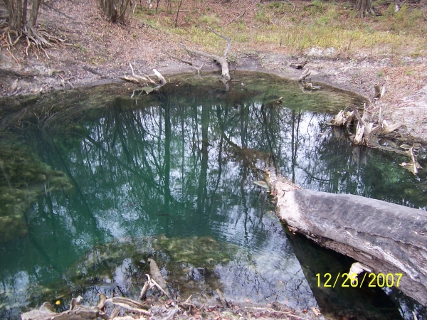
Description - Turtle Spring pool measures 30 ft north to south and 66 ft east to west. The depth over the spring vent is 21.4 ft. The vent is an elongated fracture beneath a limestone ledge. The spring pool bottom is sand and limestone. The spring water is clear and greenish. There was a small boil in the center of the pool during May 2002. Algae are abundant on both rock and sand substrates. Several downed logs are inundated within the spring pool. The spring run is shallow, 90 ft long and 20 ft wide. It flows into the dark waters of the Suwannee River. Limestone is exposed in the shallow spring run and near the vent. Turtle Spring is situated along the Suwannee River in a cove surrounded by 15-18 ft high sandy banks. The surrounding lands are all forested with mixed hardwoods.

Utilization - The spring is undeveloped and surrounded by private land. It is locally used for swimming.
Click the map below for all mapping options.
Click to View Larger Map
Latitude: 29.847394
Longitude: -82.890286
Zone:
Coordinate System:
 Cave Diving
 Cavern Diving
 Open Water Diving
Private
Date Submitter Visbility Remarks
12/26/2007 DogDiver Milky Well, I found the site and did a dry Recon. Flow was strung and vis looked Milky.....this is on private property and landowner permission is required. With a little skill and luck you can find this site using the Lafeyette County Tax apraisers site. Lafeyette county has also renamed all the roads, so the above directions are not correct.http://www.cavediver.net/forum/gallery/showimage.php?i=7651&catid=newimages
Click here if you would like to contribute any information or resources for this system.
Description Type Date Author Remarks
Sslect Search Radius:
System Depth Cave Cavern OW Last Report Distance (mi)
 Overview Information Available for Jug Spring  Jug Spring 80 True True False 1/12/2023 12.1
 Overview Information Available for Sunbeam Spring  Sunbeam Spring 80 True False False 10/15/2022 9.1
   Syphon Creek - Myrtle's Fissure 95 True False False 2/29/2020 9.4
 Overview Information Available for Wilson Spring  Wilson Spring True False False 7/18/2015 8.7
 Overview Information Available for Rock Bluff Spring  Rock Bluff Spring 65 True False False 5/10/2015 3.8
   Syphon Creek - Resurgence True False False 6/23/2011 9.4
 Overview Information Available for Branford Spring  Branford Spring 101 True False False 1/16/2010 7.8
 Overview Information Available for Sun Springs  Sun Springs True False False 11/14/2009 10.2
   Syphon Creek - Swallow Hole 188 True False False 9.8
   Syphon Creek - Lil' Awesome 80 True False False 9.9
   Syphon Creek - Track One True False False 9.6