| 10/27/2023 |
GUY BRYANT |
50-60 |
The current is about the usual normal high flow. Vis 50-60 slight tannic with lots of particulates. Average depth 120 ft. Lots of bacteria on the walls, ceiling and floor. Not like it was 40 years ago with nice clean walls. Getting in and out is now more difficult since the last hurricane deposited trees on the normal path to the water. |
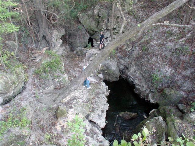
| 4/22/2019 |
Kyle Nevins |
15 |
Flow was extreme cleared some sticks that were wedged in the fissure but could not pull myself deeper then 40 foot due to flow. Also 2 trees are down on the path to the spring. |
| 7/9/2017 |
Elisha Gibson |
~20 |
Wow, a week makes quite a difference in this cave! The water was markedly more tannic and showing about a one degree increase in temperature. Flow seemed higher in the crack, but the syphon pull towards Suwannacoochee was lower, and flow in general seemed lower after the first 200 feet or so. Particulate was same as first dive, not too much. |
| 7/1/2017 |
Elisha Gibson |
20 |
My first time in the system. Entrance was relatively easy due to low water level. We were able to gear up in sidemount on the rocks towards the river. No rope required. Flow was strong coming out of the crack (can't compare to the usual), but pumping clear water. The line was a little loose coming down the crack, but no cause for concern. The line was covered in a pile of debris at the bottom of the crack, but we were able to unearth it and follow the main line. We stay left at the T's and eventually came to the backward arrows signaling the halfway point to Suwannacoochee. The flow began to change and we decided to head back out. We heard the train above on the way out and the vibrations dislodged some silt from the ceiling. We had decent visibility on exit. |
| 6/4/2017 |
Jason Richards |
20-25 |
Flow is fair to moderate, entrance line to the bottom of the shaft is intermittent. Rest of the lines are covered in growth but intact. |
| 12/12/2015 |
Stacy Dreher |
15-20' |
The river is low which makes the entrance easier right now for side-mount. You can kneel on the rocks nearest the river to suit up. Flow was noticeable but not bad and the vis was okay. |
| 9/8/2010 |
Scott |
15 feet |
The river level of the Suwannee is down and so is the flow inside Edwards. The flow coming up the fissure was not as bad as when I usually dive here. Inside the cave, the flow was down and it was a much easier swim than it was an April. |
| 9/19/2009 |
Craig Gaffka |
Bad |
Went to dive Edwards but had to cancel the dive. Viz in the basin was 8' at best and very dark and tannin. |
| 4/19/2008 |
Dogdiver |
5 |
With this site so close to the suwannee it remains tannic. But man what a flow...should be divable in a few weeks. |
| 1/7/2008 |
DogDiver |
80 |
Flow is down, nice vis. Suwannee rising. |
| 10/31/2007 |
Craig |
20-30 |
Good conditions, water is brown as almost always with about 20-30' of viss. Flow was notably down also. |
| 7/23/2007 |
Ken Anderson |
100 |
Did a recon dive after diving Anderson. Use extreme caution getting and out of this site. Very steep and moss covered rocks and path. Take ropes to help you out. The flow is strong, vis 100 Line in good shape. Dropped down the verticle shaft to 106 feet where it leveled out and turned the dive to return with mix. As with Anderson, no is the time to dive this site with the Suwannee level so low... |
| 2/15/2007 |
akcaver |
0 |
Stopped by the spring on 2/10 and found the viz to be blown due to the higher river levels. Decided not to dive, less than 2 viz in the pool. The past couple weeks had 30 viz and low flow, hopefully its back to that soon. |
| 2/15/2007 |
akcaver |
0 |
Stopped by to check out the spring on 2/10, discovered the spring was |
| 1/3/2007 |
SLIM |
30 |
Flow down, once down under the fissure, the vis was clear with the walls very dark and the line was very dark and covered in trash and leaves. Noticed many sections of nasty looking silt pilied up ready to be distruvebed.
|
| 8/20/2006 |
Sam M |
15' |
Dove Edwards this evening. Pretty solid flow, but not as crazy as it can be. Vis was decent, maybe 20', at best, but there was a lot of particulate in the water, and at times vis dropped considerably. Got to hear a train go overhead... always cool. |
| 4/9/2006 |
Jay Titen |
20' |
Went to Edwards today with the intent of diving it. The flow was intense. It was so strong that you could hear it crashing against the rocks before it dumped into the river from 40yards away. The water was clear and you could see a good ways down the fissure. |


 Portions of the following information were taken from Florida Geological Survey Bulletin 66.