 Portions taken from www.CaveBiology.com
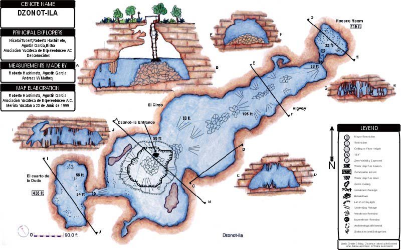
 Cenote Dzonot-ila is located 52 km south of Merida, near the town of Abalá. This cave is one of the most beautiful cenotes in all the state of Yucatan due to its large and pristine underwater stalactites and stalagmites. The entrance consists of a rectangular well shaft, about 1.5 by 2 m and 12 m deep. This well provides water for cattle kept by the owner of the hacienda. A ladder constructed of narrow gauge train rails is used to descend the well. At one time, horse drawn rail carts were used as an important means of transport in Yucatan. These systems are still in use on some of the little towns in the Yucatan.
At the bottom of the ladder, the shallow top of a sizable breakdown mound allows divers to gear up while standing chest deep in water. This cenote is divided in three sections - the main cave, called the Highway, the Rococo Room and the Doubt Room. The Highway is the largest section of the cave - 40 m wide and 30 m high. The floor of this passage consists of a ridge of large breakdown blocks running down the center with deepest depths along the walls. At the far end of this passage, the cave appears to stop in breakdown. However, a small restriction, with very reduced visibility and barely passable with double tanks, leads to the Rococo Room. This room is exceptionally beautiful and one of the most highly decorated rooms in the state of Yucatan. The Rococo Room is about 30 m wide, but no more than 2 m high. Stalactites go from the roof almost to the floor while stalagmites go from the floor to almost to the roof. Sidemount divers have explored the far side but found no passages going off.
At the opposite side of the entrance room from the Highway, a very tight restriction leads to the Doubt Room. This 40 m wide is only 1-2 m high, but also very well decorated with stalactites and stalagmites.


