 Portions of the following information were taken from Florida Geological Survey Bulletin 66.
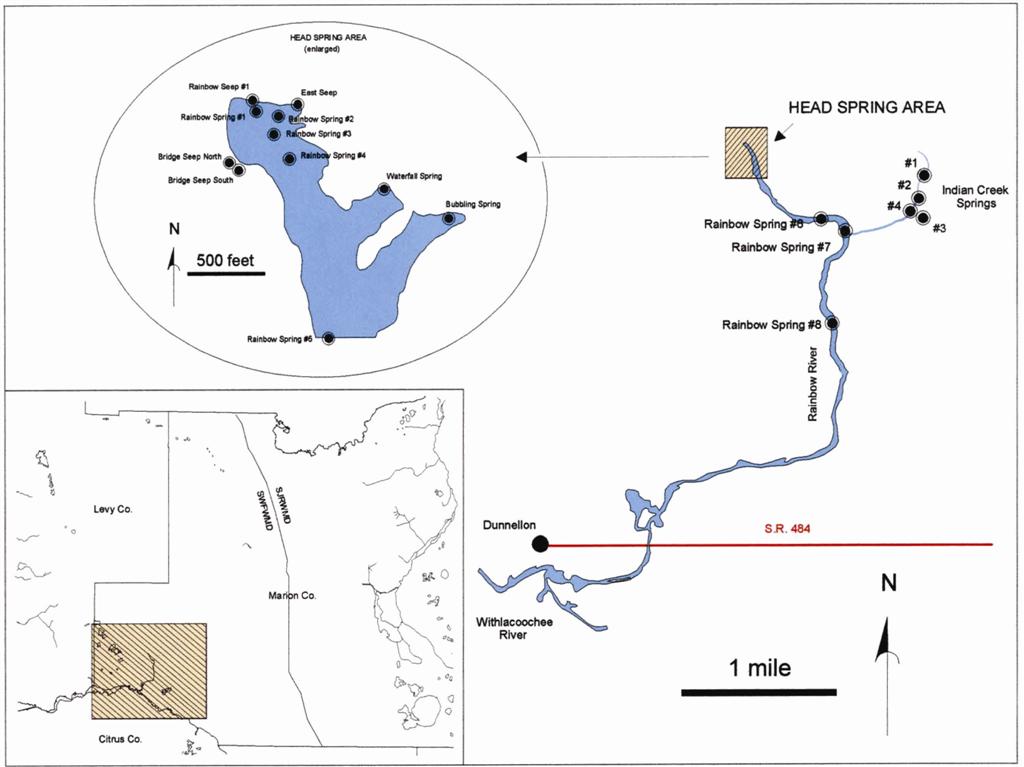
The Rainbow Springs Group is approximately 3.5 miles north of Dunnellon and
forms the headwaters of the Rainbow River. From the intersection of US 41 and CR 484 in
Dunnellon, drive north on US 41 approximately 3.7 miles to a large sign on the east
(right) side of the road indicating the entrance to the Rainbow Springs State Park, at 83rd
Place Road. Turn east (right) onto 83rd Place Road and continue 0.8 miles to the
parking area near the head of the Rainbow River.
Description - Rainbow Springs Group forms the Rainbow River, which flows
approximately 5.7 miles south to the tannic Withlacoochee River. Surrounding
land has high rolling sand hills with pine forest, agricultural fields and developed areas.
Springs, in addition to those at and near the head of the Rainbow River, discharge from
numerous limestone crevices and sand boils in the bed of the river and along the banks
through the upper 2 miles.
RAINBOW NO. 1 - Rainbow No. 1 is at the head of the Rainbow River. The spring pool
measures 330 ft north to south and 360 ft east to west. The large spring
pool has multiple vents. The depth over the main vent is 9.9 ft. The bottom is sand
with occasional limestone boulders. Water is clear and blue. A boil is visible over the main
vent. Aquatic vegetation is patchy, including some exotic aquatic vegetation. Motorized
boats are prohibited, but the area is accessible by canoe or kayak. There is a designated
swimming area on the west side of pool. Land around the northern half of the pool rises
sharply to approximately 25 ft above the water. Rainbow Springs State Park facilities
are situated on the high ground to the north. Live oak and pines are abundant on high
ground. There is a dense hardwood-palm swamp forest along the pools east and west edges.
RAINBOW NO. 4 - Rainbow No. 4 is approximately 350 ft downstream from Spring
No. 1. It issues from a conical depression at the bottom of the river. The circular spring pool
measures approximately 75 ft in diameter. The depth measured over the vent is 10.9
ft. Water is clear and pale blue. A boil is not visible. Aquatic grasses sway in the
current with very little exotic aquatic vegetation. Algae are present but are not dominant.
This spring is located within the State Park no motorized boat zone. Land on both sides of
the river is low lying and harbors pristine hardwood swamp forest.
RAINBOW NO. 6 - Rainbow No. 6 is just off the south bank approximately 0.4 miles downstream from the headwaters. It emerges from the bottom of the Rainbow River
between 1 and 1.5 miles downstream from the head of the river. It issues from
a conical depression nearest the west bank of the river and forms a boil on the river surface.
The spring pool measures approximately 60 ft north to south and 75 ft east
to west. The depth measured over the vent is 16.9 ft. Limestone is evident on the
bottom of the spring. River and spring water are clear and pale blue. Aquatic grasses are
common in the spring pool. Exotic aquatic vegetation is present on the south side of the pool.
Algae occur thinly on limestone substrate. High ground on the west side of the river rises
to nearly 20 ft above the water. There are some pines on the hill top. This spring is
downstream from the state park, and private houses are along the west bank. The east side
of the river is low-lying and heavily forested state land.
BUBBLING SPRING - Bubbling Spring flows into the Rainbow River from the east
approximately 200 ft downstream from Spring No. 4. The spring pool measures 45
ft north to south and 75 ft east to west. The shallow spring pool measures
only 2.8 ft over the vent. Water issues from a small crevice in the limestone. The
force of the boil pushes the water column approximately 0.5 ft higher than the surrounding
spring pool. The pool bottom is sand and limestone and the water is clear and pale
blue. This spring and its run have very rich aquatic vegetation. Algae are thinly present
on limestone substrate. Bubbling Spring is at the head of a spring run that is approximately
400 ft long. Densely forested high ground adjoins the east side of the pool and
rises to approximately 15 ft above water. There is a hardwood forest canopy over the
spring pool. The spring is within the state park.
Utilization - The uppermost portion of Rainbow River is part of Rainbow Springs State
Park. It is developed into an interpretive and recreation area with emphasis on preserving
the natural quality of the watershed. The east side of the river below the state park is state-owned and protected. The west side below the state park is subdivided into private lots,
often with houses near the rivers edge.


