United States » Mammoth Spring

  • Currently 2.8/5 Stars.
  • 1
  • 2
  • 3
  • 4
  • 5

Rated 2.8/5 stars (361 ratings) Thanks for rating this cave system!

Overview Location & Specifics Conditions Resources Nearby Systems  
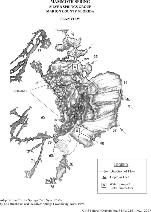
This is the largest and most upstream of the spring vents. It discharges horizontally into a large basin just east of the glass-bottom boat loading area. The vent is a horizontal, oval-shaped opening 2 to 6 feet high and about 65 feet wide at the base of a limestone wall. The bottom of the vent’s mouth is composed largely of breakdown boulders and rubble. The depth of water measured in front of the vent opening is about 34 feet. Water from at least two distinct sources (Mammoth East and Mammoth West) discharge from the cave opening. These sources differ in temperature and chemistry. The spring basin measures about 300 feet north to south and 200 feet east to west.
Click the map below for all mapping options.
Click to View Larger Map
Latitude: 29.216167
Longitude: -82.052667
Zone:
Coordinate System:
Maximum Depth: 77'
 Cave Diving
 Cavern Diving
 Open Water Diving
Date Submitter Visbility Remarks
Click here if you would like to contribute any information or resources for this system.
Description Type Date Author Remarks
 System Map Map 2007 Karst Environmental Services Adapted from "Silver Springs Cave System" Map
Sslect Search Radius:
System Depth Cave Cavern OW Last Report Distance (mi)
 Overview Information Available for Paradise Springs  Paradise Springs 140 True True True 2/23/2023 8.2