


United States » Williford Spring |
| Overview | Location & Specifics | Conditions | Resources | Nearby Systems |
 Portions of the following information were taken from Florida Geological Survey Bulletin 66.
 The spring is located on NFWMD land 23 miles (37 km) southwest of the US 231 (Cottondale) exit on Interstate 10. From I-10, travel south on US 231 approximately 23 miles (37 km) to the intersection with SR 20. Turn west (right) on SR 20 and travel 7.5 miles (12.1 km) to Herman Strickland Rd. Turn north (right) and follow the road 0.8 miles (1.3 km) to the gated spring entrance on the right.
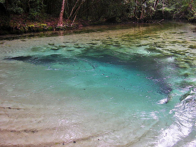
Description Williford Spring has a circular spring pool in a conical depression whose sand bottom is rippled by issuing spring currents. The pool measures 57 ft (17.4 m) in diameter. The vent is under a limestone ledge roughly in the center of the pool, and the depth measured over the vent is 10.1 ft (3.1 m). There is a sizeable boil over the vent, and the color of the water is light blue-green. There is no aquatic vegetation in the pool, and a thin layer of algae covers less than half of the limestone and sand substrates. A wooden entry stairway is located on the north side of the spring with erosion control concrete bags on either side. Williford Spring discharges through a swiftly flowing spring run that travels south for approximately 443 ft (135 m) into Econfina Creek. There are numerous other smaller springs that feed into Williford Spring run immediately downstream. Some of these springs are small trickles from limestone fissures exposed along the banks of the run. To the north and west of Williford Spring, high ground rises to approximately 15 ft (4.6 m) above the water surface. There is a small, cleared parking and picnic area on the adjacent north side of the spring. A lowland forest of hardwoods, cypress and palms hugs the spring and its run. The surrounding rolling sand hills terrain supports mixed hardwood and pine uplands. A hiking trail system is along the north side of the spring run.
Utilization Williford Spring and surrounding uplands are managed by the NWFWMD as a daytime recreation area accessible by permit/reservation only. For information on access to the spring, contact NWFWMD.
| Date | Submitter | Visbility | Remarks |
|---|---|---|---|
| 6/16/2010 | Mark Summer | 50' | I did a dive today to extend the North (#2) source tunnel at Williford Spring. I dived with sidemounted AL40s; max depth was 25 FFW and the dive time was 39 minutes. The entrance to this spring is challenging as it has crazy high flow for a four foot long tunnel leading to the cavern. Once in it is only 35 feet to the jump on the right for the North Source tunnel. Here I removed my fins, and unclipped the 40s. With the fins left on the main line and the 40s out in front of me I eased in against the gentle flow of the passage ahead. The current line ended about 10 feet in and I tied off my reel and pressed on in a tunnel that was about 25-30 inches in diameter. I went very very slowly. The old line ended on top of a small hill. From here the passage dropped back down and meandered a little left and right. It was not very tight, but a little awkward as the rocks were very snagy. At each turn I was hoping the passage would either pinch down or open up, but if just continued on at about the same size. About 35-45 feet in I could see around the bend that the tunnel went up over another small rise about six feet ahead. I stopped here to evaluate what to do. As I looked ahead the ceiling percolation descended around me, and the vis went for 50 to less than 3 feet. I guess this, because when I looked back I could no longer see my feet. Faced with the unknown difficulty of backing out of this rocky tube in greatly reduced visibility I had reached my comfort level for this dive. I locked down the reel, looped it around a rock and started moving backwards. I could not see much but just felt with my feet and kept the guide line visible just out of my right eye. I thought I was going slow, but actually must have been moving faster than on the way in since in a very short time I was back at my tie off. I noticed my reel must have pulled off here as the line was loose in the flow. I stopped at the tie off for a couple deep breaths and continued to back the last bit back to the main tunnel. Well that was easy; no where near as bad as I thought it would be when the percolation descended around me. I still had lots of gas and briefly entertained the thought of going back and fixing my loose line. Then I realized that coming back with full tanks was more prudent. The cave will always be there. I used the rest of my gas to look at the other 2 source leads in this cave; both look promising, but each has its own unique and troubling challenges. As always the scariest part of this dive is the exit out of the cavern with the high flow. No matter what you do you will go from 15 feet to 5 feet instantaneously? Best bet is to close your eyes, duck your head, blow and go. Now what is over that rise in the north source tunnel? I guess I will have to go back and find out .. |
| Description | Type | Date | Author | Remarks |
|---|
| System | Depth | Cave | Cavern | OW | Last Report | Distance (mi) |
|---|