


United States » Weeki Wachee Spring |
| Overview | Location & Specifics | Conditions | Resources | Nearby Systems |
 Portions of the following information were taken from Florida Geological Survey Bulletin 66.
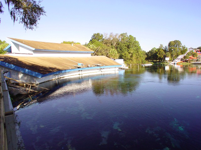
The spring is located in the town of Weeki Wachee on the west side of US 19. From the intersection of US 19 and SR 50, drive south 0.2 miles. Turn west (right) into Weeki Wachee Springs Park parking lot. The spring vent is in the large pool used for mermaid shows.
Description - Weeki Wachee Spring discharges from the bottom of a conical depression with gentle side slopes. The spring pool measures 165 ft east to west and 210 ft north to south. Spring depth is 45 ft over the vent in the center of the pool. Bare limestone is located near the vent, but none is exposed around the pool edges. The water is clear and light greenish blue, and a boil is visible in the center of the pool. Thick, filamentous algae cover the majority of the spring bottom, and there are some native aquatic grasses in the spring pool. The spring is rich with fresh and salt water fishes and aquatic turtles. The Weeki Wachee River flows westward approximately 5 miles into the Gulf of Mexico. The river flows through low-lying, densely forested swamp. The nearest high ground east of the spring is rolling sand hills terrain and gently rises to 15 ft above the water level. All uplands and land adjacent to spring are developed. U.S. 19 is approximately 225 ft east of the spring.
Utilization - Weeki Wachee Spring is extensively developed into a tourist attraction that features underwater mermaid shows with a submerged observation area. It was recently purchased from private ownership by the Southwest Florida Water Management District (SWFWMD). The District leases the land to a private firm for the continuation of the mermaid shows. Shops and facilities are located all around the spring.
| Weeki Wachee Historical Flow | ||||||||||||||||||||||||||||||||||||||||||||||||||||||||||||||||||||||||||||||||||||||||||||||||||
| Date | Flow | Type | ||||||||||||||||||||||||||||||||||||||||||||||||||||||||||||||||||||||||||||||||||||||||||||||||
| 8/27/1984 | 259 ft3/sec | Max | ||||||||||||||||||||||||||||||||||||||||||||||||||||||||||||||||||||||||||||||||||||||||||||||||
| 8/28/1984 | 259 ft3/sec | Max | ||||||||||||||||||||||||||||||||||||||||||||||||||||||||||||||||||||||||||||||||||||||||||||||||
| 5/13/2009 | 93 ft3/sec | Min | ||||||||||||||||||||||||||||||||||||||||||||||||||||||||||||||||||||||||||||||||||||||||||||||||
| Date | Submitter | Visbility | Remarks |
|---|---|---|---|
| 4/28/2012 | Andy Pitkin | 60-100' | Scootered to the mega T to change the radio locator battery pack. On the way checked out possible leads on the west side of the passage between there and the Dead Marshes T. Unfortunately nothing going, just a large room over 150' across. Visibility in the 70-80' range, making identification of exact passage configuration difficult. Some places as high as 100', but mostly less with fine particulate haze in the water. |
| 1/14/2012 | Idee B. | 100' | Moderate flow, great visibility, heavy moss patches on the sand, saw two manatees wintering in the spring. Castle roof is approx 5' beneath water's surface. Shallows allowed for fantastic ambient light photos. |
| 3/13/2011 | Walter Pickel | 100 | Since the discharge rate has lowered to where we can do some training, we did some line work in the crack and conducted some familiarization dives this week. Flow is still immense and not ready for mission dives but it was nice to feel the power of Weeki after we had been shut out since 2009. |
| 6/17/2009 | Walter Pickel | 100 | Had a great dive tonight doing some filming with Liquid Productions, LLC. I manned the Death Ray in the fissure...Amazing to see the fissure lit up like that. Flow and water level in the basin is WAY up; the castle is no longer exposed to the surface. We are having to come to grips with the fact that Weeki Wachee may be lost for this season. Hopefully, we get a sustained period of high flow to open up Twin Dees and start back up there. |
| 5/1/2009 | Walter Pickel | 100' | Visibility in the cave remains good even with the decreased flow. Visibility in the Witch's Den is reduced but beyond Sheck's is still 100 . For more information on the current exploration, check out the Karst Underwater Research Blog |
| 4/30/2009 | Mugwump | 0' | Historical record flow...95cfs...with two months or so until the rainy season starts. I bet it hits 85cfs before it's over... |
| 4/2/2009 | Walter Pickel | 100 | The 2009 Exploration is in full swing. We were able to stage 4 scooters and 6 bottles in the cave for Saturday's upcoming mission dives. They will be the first closed circuit mission dives of the year.
For more information about the 2009 Weeki Wachee Exploration visit the Karst Underwater Research Blog. |
| 3/22/2009 | SRS | 100'-plus | The KUR team, 2009 version, has begun ramp-up dives in WW for the season. Flow is at 100 cfs or so, and dropping pricipitously due to the extrememe drought. Orientation dives were made yesterday by a new group of experienced CCR divers, using OC for the first shot at entry/exit, lead by veterans Corey Mearns and Paul Heinerth, for their first exerience in the cave....next time CCR's will be used. Thanks to all who helped, in water and out! |
| 8/25/2008 | Mugwump | 100 | Flow has already exceded the highest level in 2007, with three months to go in tropical storm/hurricane season...!!! |
| 7/4/2008 | SRS | 100' | Flow is not coming down like last year (too much rain)...inhibits the ability to get setup gear (bottles, scooters, etc.) into the cave, hence minimal exploration can be accomplished. Did a short OC swim dive to White Death jump (approx. 500' into the cave proper) last night, flow is cranking up, but do-able with a clean OC system (no stages, too much drag!). Viz 100'-plus. Exiting is an experience...to say the least, at one point , around 160' or so, the cave is only about 6 ft. wide by 4 ft. high...imagine 105 cfs blowing through that and you'll get an idea! Flow is now right at the "official KUR protocol" limit for diving activities in the cave. Unless it drops significantly, there probably won't be any real exploration done this year. Mother Nature just teases...and doesn't get tired! |
| 6/11/2008 | Robert Brooks | 100+ | first team dive of the year in to the cave . ( It rocked) |
| 3/9/2008 | Walter Pickel | 100 | The KUR team worked on planning the installation of the habitat as well as did some team training. The flow is up and has been affected by the local rains. Also, there were 6 adult manatees and 2 juveniles in the run. |
| 2/3/2008 | Walter Pickel | 100 | We performed some line maintenance as well as training new team members. Flow is around 120cfs and you can feel it! Water color is GORGEOUS right now. Much bluer than last season. |
| 7/14/2007 | Walter Pickel | 100+ | Brett, Paul, Corey Mearns shoot video of the first 2,000 feet of the system using Silent Submersion's new Death Ray and add 1,600 near Mount Doom; they confirmed (via 3 computers) a depth of 403 ffw at the bottom of Mount Doom - and this was not on the "very bottom." From there the tunnel got shallower again (in the 370ffw range) but ended in a room with a much smaller springing tunnel extending off of it. After doubling back a short distance, they found main trunk again and added the remainder of the line there. In the main tunnel near the end of the dive, the team passed a section that looked as if they may have hit the spot where the F well's drilling breached the ceiling of the tunnel. The large, main tunnel (where the "F" well connection may have been made) continues, but the dive was terminated on time.
Bottom Time: 2 hours Deco Time: 9.25 hours Exploration Team: Brett Hemphill, Paul Heinreth, Corey Mearns Support Team: Robert Brooks, Jackie Clark, Joel Clark, Eric Deister, Kelly Deister, Lindsey Hodges, Corey Mearns, Dali Mearns, David Miner, Jeff Petersen, Walter Pickel, Micheal Poucher, Sandra Poucher, Steven Straatsma, Ben Wilcher, Bert Wilcher |
| 6/27/2007 | Walter Pickel | 100+ | The dive plan was to explore simultaneously the two leads off of Helm's Deep, Brett, on his KISS CCR and Paul on his Dive Rite Optima CCR scootered to Helm's Deep. From there, Brett took the more southern trending tunnel. Paul followed for a short distance and then separated to explore a large side tunnel heading west. Brett added approximately 1,900 feet of line through amazingly large tunnel (averaging 70 feet high by 100 feet wide) to a depth of 342 ffw until the tunnel began to pitch steeply downward. This drop off was named Mount Doom. Brett also identified two more possible leads along the western wall between Helm's Deep and Mount Doom. Paul added approximately 1,200 feet of line in the large west tunnel. However, this tunnel, nicknamed the Dead Marshes Tunnel had no discernible flow, the water was darker and clearly stratified and stagnant with bacteria colonies. At present time, the question remained if this could be the connection to Twin Dees, since the spring has been stagnant for the last two years.
Bottom Time: 2 hours Deco Time: 7.5 hours Exploration Team: Brett Hemphill, Paul Heinreth Support Team: Robert Brooks, Eric Deister, Lindsey Hodges, Jeff Petersen, Walter Pickel, Micheal Poucher, Sandra Poucher, Scott Pulliam, Ben Wilcher, Bert Wilcher |
| 6/16/2007 | Walter Pickel | 100+ | On a solo scooter dive with his KISS CCR, Brett added almost another 1,300 feet of line. Just before the White Death restriction, he spotted the real primary tunnel and followed it to the very large room, dubbed the River Room, with two very minor tunnels extending off of it. Brett doubled back, realizing that the primary tunnel must have split on him, again. With tunnel this large and only one diver's light, the "main" tunnel isn't as obvious as you would expect. Again, back in the true primary tunnel, he scootered on southward, passing through a short, restricted area of breakdown collapse which then opened up back into large tunnel and then yet another amazingly large room dubbed, Helm's Deep. On the southern end of the room, two large leads appeared evident.
Bottom Time: 1.5 hours Deco Time: 4 hours Exploration Team: Brett Hemphill Support Team: Robert Brooks, Jackie Clark, Joel Clark, Eric Deister, Kelly Deister, Lindsey Hodges, Corey Mearns, Dali Mearns, David Miner, Jeff Petersen, Walter Pickel, Micheal Poucher, Sandra Poucher, Ben Wilcher, Bert Wilcher |
| 5/27/2007 | Walter Pickel | 100+ | Brett Hemphill added just over 700 feet of line past the restriction/breakdown where Sheck's line with depth averaging 250ffw. On this solo swim dive with his KISS CCR, Brett Hemphill swam to the end of Sheck's line and then found an easily passable keyhole restriction through the breakdown collapse. After the restriction, Brett found himself in very large tunnel that averaged 15 feet high by 50 feet wide, with breakdown covered in a layer of silt and sand giving it the appearance of a winter mountainscape. Then the tunnel size expanded to average 25 feet high by 80 feet wide. He followed the tunnel and flow westward to another restriction at a depth of 278ffw, dubbed "White Death" because of the clay composition of the tunnel. We suspect the tunnel beyond this restriction is the primary source of the silt in the first 1,200 feet of the system and it is probable that this passage leads to a sink that was covered when the Weeki Wachee parking lot was laid. Bottom Time: 1.5 hours Deco Time: 4 hours Exploration Team: Brett Hemphill Support Team: Eric Deister, Brett Hemphill, David Miner, Jeff Petersen, Walter Pickel, Micheal Poucher, Sandra Poucher, Bert Wilcher |
| 5/15/2007 | Walter Pickel | 150 | Continued line work and visual documentation for SWFWMD. Flow is still ripping at the bottom. |
| 4/5/2007 | Walter Pickel | 150 | Did some further line management and cleaning for SWFWMD. Flow is down a bit but still ripping at the bottom (entrance to big room). |
| 2/24/2007 | Bert Wilcher | 150 feet | Dove the mermaid lagoon this afternoon, no manatees but a lot of mermaids and lifeguards in training for eye candy. |
| 5/18/2006 | Walter Pickel | 100 | Managed the line as Brett and Eric installed the line. SWFWMD reported that the flow was 138 ft3/s. Hard to believe as it seemed much stronger than that. The flow seemed up from last week as well.
Remember that this is a permit dive. The red line that was installed is in support of the permit diving being done here. |
| 5/12/2006 | Eric Deister | 100 | Trying out the new permit, we did a test dive to check out the flow. Looks like the old lines in there will be pulled and new line installed in the coming weeks. Viz was spanking below 160. |
| Description | Type | Date | Author | Remarks |
|---|---|---|---|---|
| Web Site | ||||
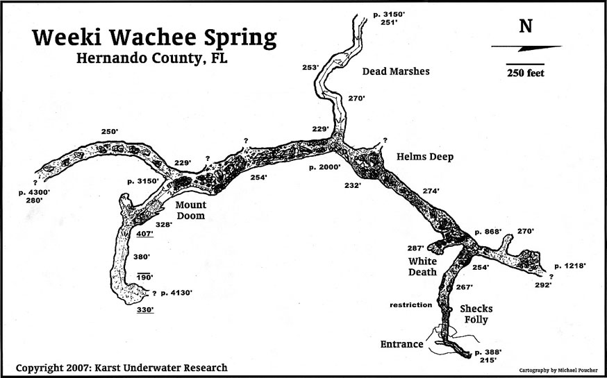
| Map | 2007 | Karst Underwater Research | Drawn by Michael Poucher | |
| Map | 2007 | Karst Underwater Research | Drawn by Michael Poucher | |
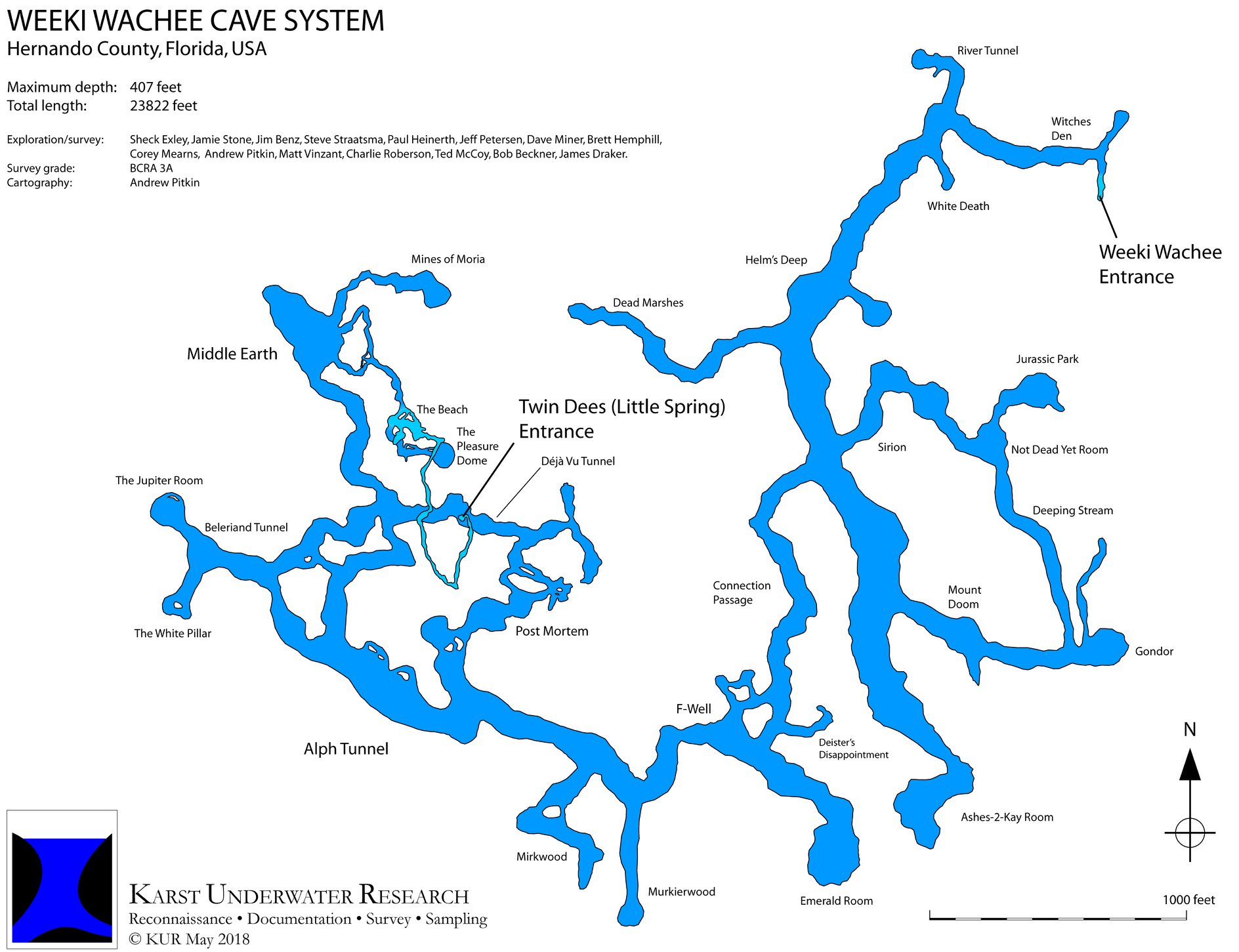
| Map | 2018 | KUR | ||
| Vimeo | 2010 | Liquid Productions | ||
| Video | 2009 | Pickel & Hemphill |
| System | Depth | Cave | Cavern | OW | Last Report | Distance (mi) |
|---|---|---|---|---|---|---|
| 167 | 3/14/2024 | 8.1 | ||||
| 315 | 3/14/2024 | 3.4 | ||||
| 165 | 7/15/2023 | 2.3 | ||||
| 143 | 4/30/2023 | 3.2 | ||||
| 140 | 11/1/2022 | 8.3 | ||||
| 198 | 9/30/2022 | 8.5 | ||||
| 197 | 7/18/2021 | 6.3 | ||||
| 60 | 3/22/2020 | 3.3 | ||||
| 300 | 5/27/2017 | 2.7 | ||||
| 180 | 1/3/2015 | 8.2 | ||||
| 335 | 8/3/2013 | 0.5 | ||||
| 110 | 5/22/2013 | 10.3 | ||||
| 360 | 12/23/2010 | 2.7 | ||||
| 192 | 12/6/2009 | 3.5 | ||||
| 180 | 11/29/2009 | 10.4 | ||||
| 120 | 10/10/2009 | 10.6 | ||||
| 9/19/2009 | 12.5 | |||||
| 230 | 1/11/2009 | 9.4 | ||||
| 1/10/2009 | 10.8 | |||||
| 240 | 9/23/2008 | 3.4 | ||||
| 12/29/2007 | 7 | |||||
| 200 | 9/2/2007 | 10.2 | ||||
| 315 | 6/2/2006 | 9.6 | ||||
| 210 | 11/20/2005 | 3.8 | ||||
| 214 | 1.6 | |||||
| 250 | 9 | |||||
| 2.7 | ||||||
| 58 | 2.1 | |||||
| 50 | 3.7 | |||||
| 60 | 2 | |||||
| 120 | 10.5 | |||||
| 120 | 10.6 | |||||
| 3.4 | ||||||
| 1.9 | ||||||
| 40 | 3.3 | |||||
| 8.7 |