


United States » Cathedral Sink |
| Overview | Location & Specifics | Conditions | Resources | Nearby Systems |
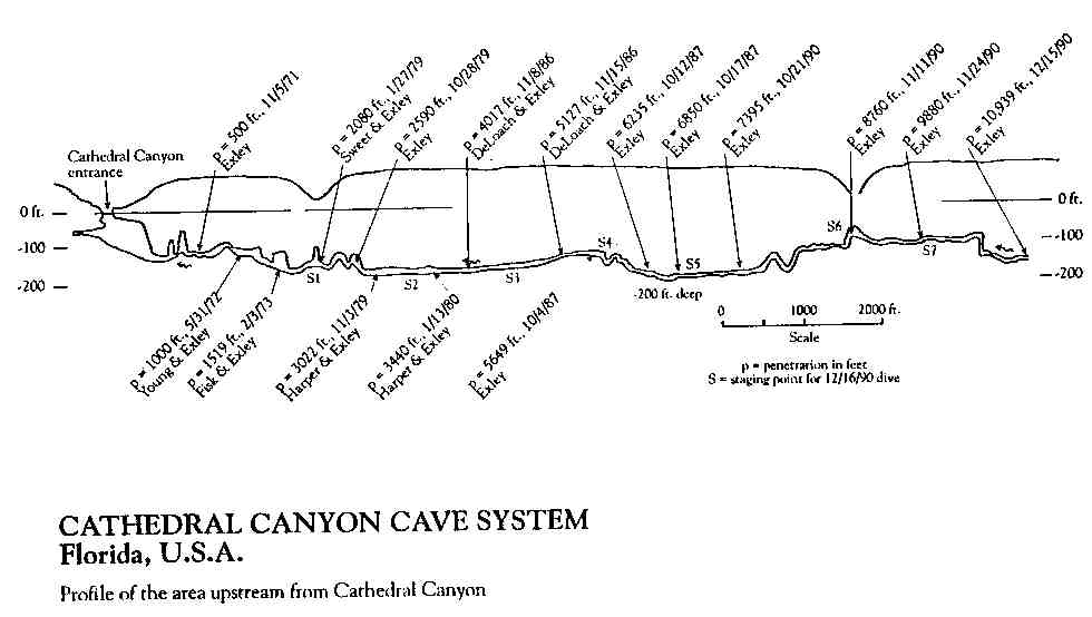
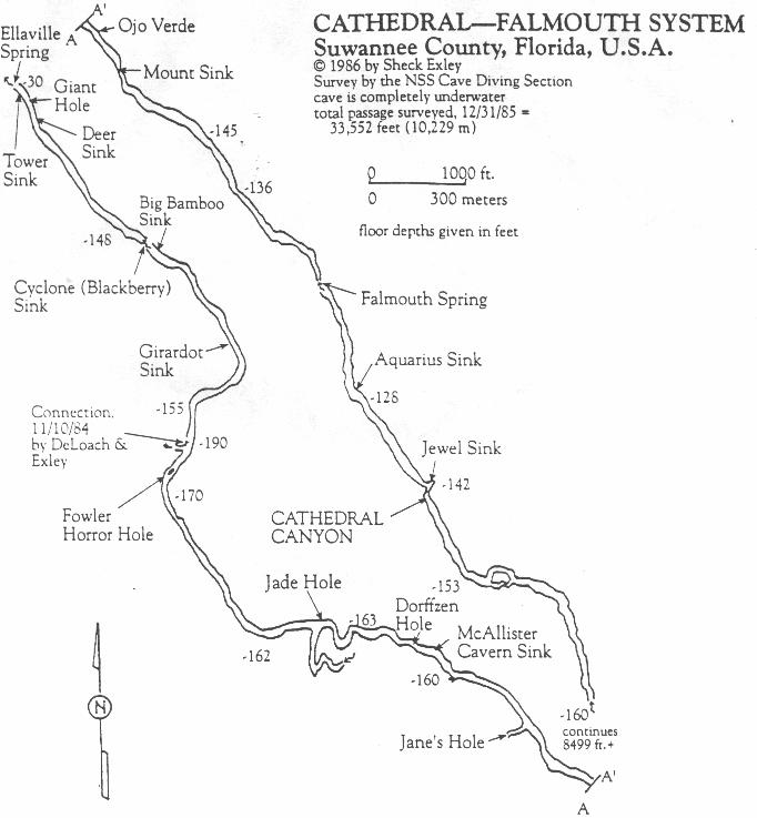
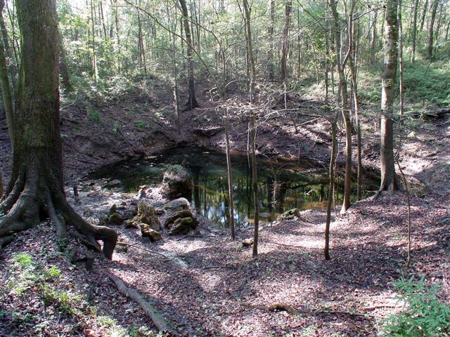 Sheck Exley donated approximately four acres containing Cathedral Sink to the National Speleological Society Cave Diving Section. The property is the furthest upstream of 18 known entrances into the Falmouth system that eventually empties into the Suwannee River at Ellaville Spring within the Suwannee River State Park. The system was explored and mapped by Sheck Exley, Mary Ellen Eckhoff, Paul DeLoach, Dave Fisk, L. Hall, John Harper, Lewis Holtzendorff, Randy Hylton, Bill Main, Clark Pitcairn, Wes Skiles, Bill Stone, Dale Sweet, John Zumrick and Court Smith, and contains over 41,020 feet of passage. On December 16, 1990, Sheck established what was then a record penetration of 10,939 feet on a multi-stage dive lasting nearly 12 hours, including decompression. (Upstream exploration was extended to over 17,000 feet in 2004.)
 When exploration first began in Falmouth-Cathedral System, the visibility in Cathedral was often 100 feet or more. Since then, changes in the aquifer have reduced visibility to only a few feet most of the year. Occasionally, conditions allow the visibility to improve to 40 feet or so. Because of this, and the depths involved, Cathedral is considered an advanced cave dive with depths to 200+ feet and the access policy is written with this in mind.
| Date | Submitter | Visbility | Remarks |
|---|---|---|---|
| 12/29/2014 | Admin | CLOSED | The owner of the system, the NSS/CDS, has decided to close the system due to the condition of the deck, the low visibility, and that the line is buried in many places. |
| 12/26/2014 | FW (via CDF) | 5 | Hmmm, where to start... The planking on the deck is rotting in places. I flagged the worst of in near the steps going down to the water. The original deck that Sheck Exley installed is not rotten, but has moved several feet away from shore, and toward the cave entrance. We never found the line from the steps to the cave. I ran a line from the steps, but it took me 15 minutes to find the descent line. The original tree it was attached to at the top rotted away a few years ago. Someone had put a red plastic jug in it's place, but that was sunken. I found it down at about 45' into the entrance drop. We put a lift bag onto the red jug to hold up our deco bottles. Then we followed the line down to the bottom. It was very slack, so I tied a big knot into it to take up the slack. We got to the bottom and dropped our travel gas just a little past the bottom of the cavern wall, where the descent line changes to 1/4 inch line. The viz at the bottom was only 5'. We went ahead in spite of the bad viz, just to see conditions at the bottom. We followed the line a hundred feet or so, and found it buried in sand. I tied a jump reel, and searched for the line past the buried part. It was at least 50' before I found the line again. We swam another 50' and it was buried again. This time only for 15' or so. We swam another 50' or so, and found the line buried again. I didn't want to use my last spool, so my buddy gave me one of his. After 50' more of buried line, and seeing a 40' stop on my computer, we called it and headed back to deco. |
| 1/27/2013 | Tony Flaris | 15-20 | No flow, water clear, slightly tannic, no particulate. Main line needs re-working |
| 1/14/2011 | FW | 20' | No current, 20 vis on the Jewell sink line. |
| 2/8/2009 | Richard Blackburn | 30 | Water was clear, sink covered with duckweed. A lot of particulate in the water. |
| 11/28/2006 | Barbara Dwyer | clear, flowing under duck weed | we walked through to see the site (did not dive). It was lovely in there. The water looked clear below the duck weed. The gang's done a nice job at the site. |
| 10/4/2006 | caver | 15' | Lower viss and low to no flow |
| 12/28/2005 | SLIM | 30 | Walls still dark. |
| Description | Type | Date | Author | Remarks |
|---|---|---|---|---|
| Admin | ||||
| Map | ||||
| Map |
| System | Depth | Cave | Cavern | OW | Last Report | Distance (mi) |
|---|---|---|---|---|---|---|
| 130 | 4/2/2024 | 10.9 | ||||
| 145 | 10/27/2023 | 3.1 | ||||
| 125 | 4/22/2019 | 3.1 | ||||
| 80 | 7/2/2017 | 3.3 | ||||
| 70 | 6/18/2017 | 10 | ||||
| 12/8/2016 | 4.4 | |||||
| 200 | 1/1/2014 | 0.4 | ||||
| 208 | 9/4/2011 | 6.3 | ||||
| 8/4/2010 | 6.5 | |||||
| 3.2 | ||||||
| 130 | 9 | |||||
| 6.3 | ||||||
| 7.2 | ||||||
| 128 | 0.2 | |||||
| 148 | 2.3 | |||||
| 162 | 1.6 | |||||
| 9 | ||||||
| 40 | 6.4 |