


United States » Thunderhole |
| Overview | Location & Specifics | Conditions | Resources | Nearby Systems |
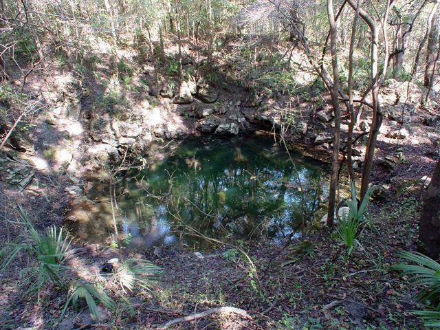 Located in Madison County, Thunderhole Cave is an offset sink from the Withlacoochee
River and is privately owned by Tom Morris his permission is required to dive it.
Some of Tom's requirements include having an Abe Davis and no scootering.
Located in Madison County, Thunderhole Cave is an offset sink from the Withlacoochee
River and is privately owned by Tom Morris his permission is required to dive it.
Some of Tom's requirements include having an Abe Davis and no scootering.
Entering the shallow entrance requires negotiating through a small opening and several rocks. During the summer months the sinkhole basin has an algae bloom hindering visibility.
The upper section is usually very clear but can sometimes have limited visibility. After following the mainline for about 500' you will be at The Well. The Well is shaped like a teardrop, with a width of 30' and length of 60'. It starts at about 65' and continues to a bottom depth of 120'. At the bottom of the well, there is minor restriction. 50' beyond the restriction is the T (marked with an old Goodman handle).
Going right on the T is downstream. You will 100% know by the flow going into the downstream side. You can count on at least doubling your time out from your time in. As one would expect, going left at the T is upstream. Both the downstream and upstream passages are uniquely different. The upstream passage has some huge goethite formations.
| Date | Submitter | Visbility | Remarks |
|---|---|---|---|
| 8/1/2011 | Jeff Petersen | 60 | Basin level was the lowest I've ever seen it in 20 years - decreased pressure-based depths throughout the system by ~9'. Great dive. Wall-to-wall visibility troughout and no particulate. Moderate flow downstream with great visibility. |
| 12/16/2007 | Gene Page | 70 Feet | Sean Denney and I dove Thunderhole yesterday (15 Dec. 2007) after getting Tom's permission. (Thanks Tom....) We found the viz to be good overall and the temp. to be 69. The lines were easy to follow and the drop down the Well is fantastic. After marking the exit line, we swam about 1400 feet upstream before turning. Our dive time was around 75 minutes and our max depth was 147 ffw. |
| 10/30/2005 | Walter Pickel | 20' - 30' | Although we thought the viz upper section would be better it wasn't and was pretty consistent with the entire system. Both lines (gold & knotted) are still in place in the system and are both in pretty good shape. We ended up doing about 500' downstream then 500' upstream. The flow in the downstream was definitely strong. The temperature of the system was also a nice 69°F. However, there was a nice milky thermocline at about 62' if you wanted to get warm. |
| Description | Type | Date | Author | Remarks |
|---|
| System | Depth | Cave | Cavern | OW | Last Report | Distance (mi) |
|---|---|---|---|---|---|---|
| 130 | 4/2/2024 | 4.8 | ||||
| 145 | 10/27/2023 | 3.3 | ||||
| 125 | 4/22/2019 | 3.2 | ||||
| 80 | 7/2/2017 | 4.7 | ||||
| 70 | 6/18/2017 | 4 | ||||
| 12/8/2016 | 3.6 | |||||
| 200 | 12/29/2014 | 6.3 | ||||
| 200 | 1/1/2014 | 6 | ||||
| 208 | 9/4/2011 | 0.4 | ||||
| 8/4/2010 | 1.4 | |||||
| 40 | 0.4 | |||||
| 7.6 | ||||||
| 130 | 3.4 | |||||
| 9.4 | ||||||
| 128 | 6.1 | |||||
| 148 | 4.1 | |||||
| 162 | 4.7 | |||||
| 120 | 7.2 | |||||
| 3.4 | ||||||
| 9.2 | ||||||
| 3.1 |